Progress in Research on Mean Soil Moisture Prediction and Remote Sensing Scale Transformation Method
In the globe, soil moisture is a vital factor for hydrological, carbon-nitrogen and energy cycle processes. Remote sensing reversion is the main method to obtain large-scale surface soil moisture content. However, the soil moisture acquired by remote sensing reversion (such as NASA's SMAP satellite data) must be validated and calibrated depending on the ground observations. Therefore, the combination of ground soil moisture observation data and spatial scale reversion is the key to remote sensing accurate inversion. Because the regional soil moisture has strong temporal and spatial heterogeneity, upscaling is made mainly through large-scale multi-point observation in current researches. However, the method used for measurement of regional mean soil moisture content is time-consuming and labor-intensive. Therefore, a small number of representative observation points need to be identified for indirect estimate. Linkage: http://www.sciencedirect.com/science/article/pii/S0022169417300525
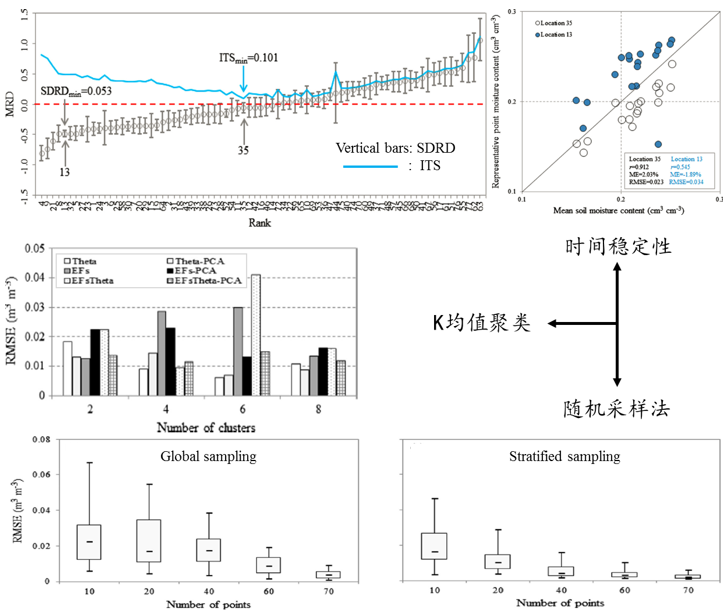
Recently, Zhu Qing Research Group systematically evaluates the accuracy of three representative methods for identifying soil mean moisture prediction sites (temporal stability, K-means clustering and random sampling). It is found by research that the temporal stability method can obtain more reliable prediction accuracy (RMSE=0.02-0.04m3/m3) and only need one representative observation site. However, this method requires lots of (at least one year) preliminary soil moisture observation values for analysis and calculation. The K-means clustering prediction accuracy (RMSE<0.03m3/m3) based on environmental factors (EFs, including soil properties and terrain indices) is slightly better than the temporal stability method and only needs a small amount of representative observation sites (<8 sites). However, this method requires soil and terrain data of the research area in the preliminary stage. The K-means clustering prediction accuracy (in most cases, RMSE<0.02m3/m3) based on phase-I soil moisture sampling data and environmental factors (EFsTheta) is significantly better than other methods but it requires soil and terrain data and a small amount of soil moisture observation values. As for the random sampling method, under the premise of ensuring a certain accuracy (RMSE<0.02m3/m3), 40 and 60 representative observation sites are needed for stratified sampling and global sampling respectively. However, this method has the advantage that no any data needs to be measured in advance. On the basis of that, based on the current soil and terrain data, accuracy requirements and the requirements for sampling site quantity, the index table is developed in the research to select the optimal method for identifying the mean soil moisture prediction sites. This research provides technical support for remote sensing soil moisture scale reversion. Its achievements were published in the international “Journal of Hydrology” (TOP, IF=3.043). The first author is Liao Kaihua, an assistant researcher.


Error Analysis of Various Methods for Identifying Soil Mean Moisture Prediction Sites (Image by NIGLAS)
