Satellite Laser Altimetry Helps Monitor Global Lake Water Changes in the Early 21st Century
Lakes are the main freshwater resources on the surface of the earth and play an important role in maintaining the stability of the ecosystem and the sustainable development of human society. In the context of climate change and the increasing impact of human activities, the stability of the global lake hydrological regime and its service function are facing challenges. However, due to the insufficient spatio-temporal representativeness of ground monitoring data and the observation of traditional radar altimetry satellites being limited to a few large lakes, the quantitative evaluation of global lake water volume changes and the understanding of the characteristics of spatio-temporal differentiation are restricted.
Professor SONG Chunqiao’s research group from the Nanjing Institute of Geography and Limnology, Chinese Academy of Sciences, firstly combined the satellite laser altimeter ICESat and its subsequent satellite ICESat-2 to form the long-term time series lake water level observation data. They conducted a quantitative study on the various characteristics of water level and water volume of natural lakes over 10 km2 in the past two decades (2003-2020). In addition, they analyzed the spatial pattern of global lake hydrological changes since the 21st century.
The results show that the two generations satellites can monitor the level-volume variation of about 6500 lakes (>10 km2), and the total water volume of observed lakes accounts for 94% of the total water volume of global lakes. About 54% of the lakes had a significant trend of water level change from 2003 to 2020 (P < 0.05), and 80% of the lakes with a significant trend of water level change showed an upward trend. As a result, the total water volume of the observed lake increased at a rate of 10.88 ±16.45 Gt/yr from 2003 to 2020. By extrapolating the area weight of the observed lake water level change rate to other unobserved lakes in the same basin, they estimated the global water volume change of about 14,700 natural lakes (>10 km2) (with a total change rate of 16.12±20.41 Gt/yr during the study period). The inner Tibetan Plateau in Asia, the Great Lakes region in North America, the Great Rift Valley in East Africa, northern Europe, and the Amazon are typical regions showing significant lake volume increases. The total increase of water volume in these five areas accounts for 60% of the total water volume in the observed lakes.
Although the water level of most of the world's lakes increased in different degrees during the study period, many lakes located in arid/semi-arid and high water-stress regions still showed significant water level decline and severe water loss. As the climate continues to warm and the water demand for human social and economic development increases in the future, these shrinking lakes will become even drier without further protection policies and actions.
The above study, entitled “Satellite Laser Altimetry Reveals a Net Water Mass Gain in Global Lakes With Spatial Heterogeneity in the Early 21st Century”, was recently published in Geophysical Research Letters (Nature Index journal). LUO Shuangxiao, a Ph.D. candidate from Prof. SONG Chunqiao’s research group, is the first author. This research was supported by China's National Key Research and Development Program and the A-Class Strategic Priority Science and Technology Special Project of the Chinese Academy of Sciences.

The map of water level (a) and volume (b) changes observed by ICESat and ICESat-2 during 2003–2020.
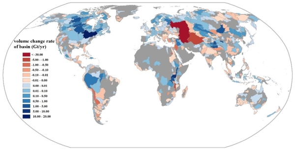
Basin-wide total water storage changes of the observed global natural lakes (>10 km2) during 2003–2020.
Paper link: https://doi.org/10.1029/2021GL096676
Contact
TAN Lei
Nanjing Institute of Geography and Limnology
E-mail: ltan@niglas.ac.cn