Characterizing the Tibetan lake growth, contributions from the glacier mass balance, and its impacts on the local human environment
The Tibetan Plateau (TP), well known as “Asian Water Tower” and “Earth’s Third Pole”, is highly vulnerable to changing climate. The TP is home to thousands of lakes representing important natural reserves of water resources on the arid lands and playing a vital role in interacting with the hydrosphere, cryosphere, and atmosphere. In the context of warming and wetting climate, the endorheic Tibetan lakes rapidly expanded, potentially impacting the local environment.
Remote sensing techniques have provided practical solutions to regional lake monitoring. However, uncertainties and inconsistencies exist in quantifying Tibetan lake water storage changes due to the spatial and temporal coverage limitations of different sources of satellite observations. These limitations lead to an unclear picture of the relationship between glacier and lake mass changes with basin-scale details. Furthermore, whether and how the rapid expansions of lake water inundation areas could influence the local human environment are gaining increasing concerns from the scientific community, governments, and the public, but has not been well addressed.
Recently the research group led by Dr. SONG Chunqiao’s group of Nanjing Institute of Geography and Limnology, Chinese Academy of Sciences (NIGLAS), has made progress in answering these questions by collaboration with researchers from HHU, KSU, UCLA, and HKPU. Their work has been published in high-impact journals, including Remote Sensing of Environment, CATENA, Science of The Total Environment, etc.
The space-borne laser altimeters enable precise measurements of inland water elevation changes. By combining the laser measurements from ICESat and ICESat-2, the research group investigated lakes’ long-term water level and storage changes (242 over 1 km2) on the TP from 2003 to 2019. These observed lakes show a mean rate of water-level change of 0.20±0.04 m/yr in 2003-2019, with 231 rising lakes (the mean rate at 0.22 ±0.04 m/yr) and 11 descending lakes (the mean rate at -0.10±0.02 m/yr). 18 lakes, seven of which are larger than 100 km2 showed water-level change rates larger than 0.50 ±0.03 m/yr. Lakes in Hoh Xil displayed the fastest water-level rise (0.34 ±0.04 m/yr on average) among all basins of the inner TP. The water storage change for the 242 observed lakes was 8.21 ±1.21 Gt/yr in 2003-2019, and the estimate can reach over 11 Gt/yr when assuming the unobserved lakes showed similar water-level change rate to the means of the observed closed lakes in the basin. “This study is expected to advance our understanding of the water level and storage changes of Tibetan lakes in the recent 20 years with higher spatial coverage” Ms. Luo, a Ph.D. candidate NIGLAS, CAS, and the first author of the paper (CATENA), said.
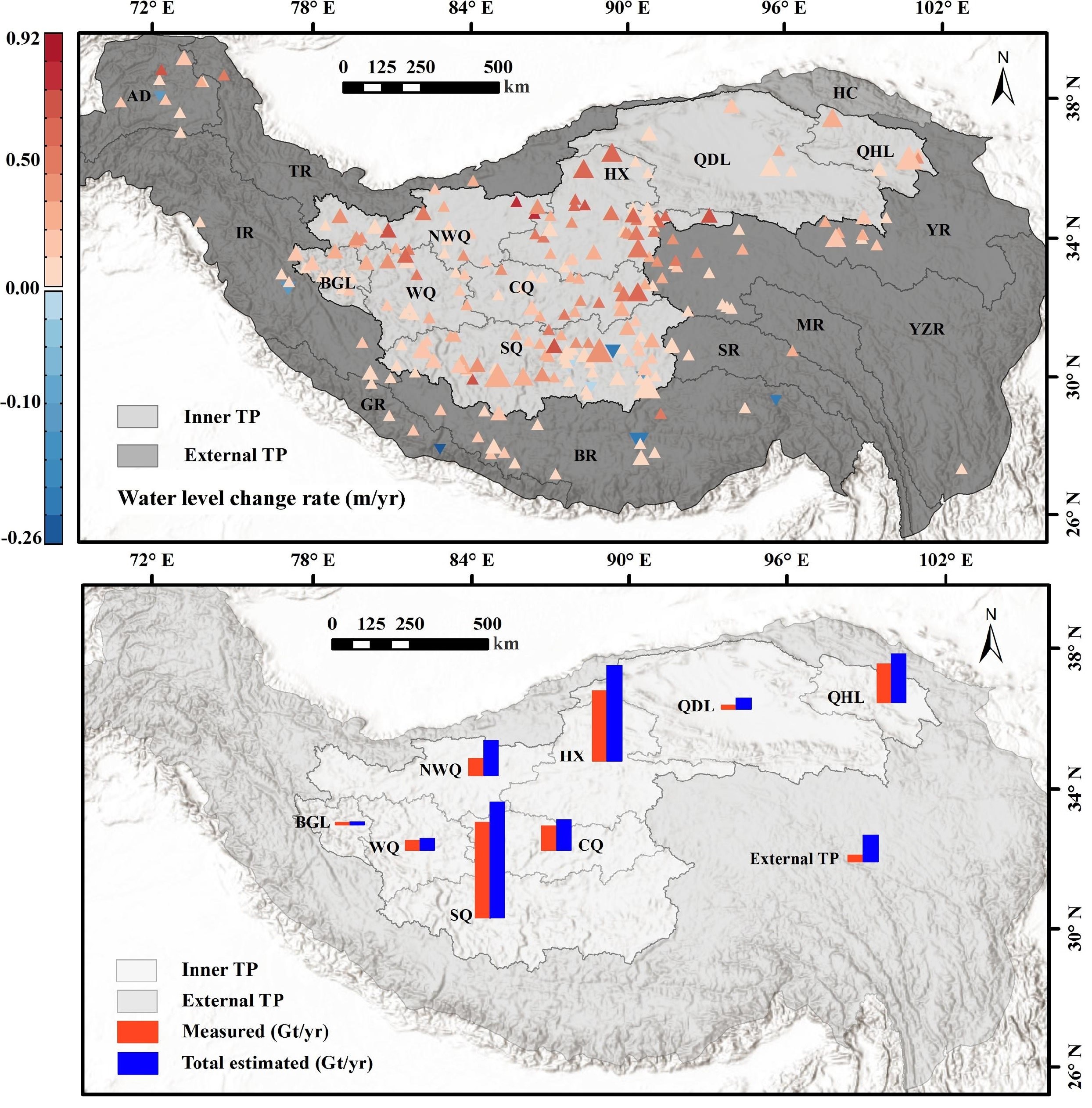
Characterizing the water level and storage changes of lakes on the Tibetan Plateau based on ICESat and ICESat-2 altimetry measurements during 2003-2019.
To quantify the contribution of glacier mass changes to lake expansion at fine basin-scale details, Dr. Song, together with Dr. Ke and other collaborators computed spatially resolved estimation of mass change in both glaciers and lakes across the endorheic TP between 2000 and 2010/14 based on multi-mission remote sensing observations. The water storage changes were examined for all lakes >1 km2 on the inner TP. These estimates reveal that the massive lake water increase (9.44±1.43 Gt/yr) was essentially not from the mass loss of glaciers which represents only about 4.7±8.8% of the lake water change (0.44±0.80 Gt/yr). The relationship in individual basins was, however, highly heterogeneous. About 20% of total lake storage gain had no causality with glacier feeding. In comparison, for 28% of lake water surplus, mainly in the northwestern TP, the positive glacier mass balance infers that glaciers retained some precipitation surplus that could otherwise have been drained to downstream lakes. For the other 52% of lake storage gain, mostly in southern and eastern regions, the glacier mass loss varied among the basins with limited contributing levels (mostly <20%). This research work highlights remarkable spatial and temporal variabilities in lake/ glacier changes on the endorheic TP and contributes to a better understanding of the role of glaciers in the recent Tibetan lake growth and the impact of climate change on the two types of water reserves.

The estimation of lake water storage variations and glacial mass balances in the endorheic Tibetan Plateau and analyses of the contributions of glacial mass changes to the lake growth in the early 21st Century.
The endorheic lake basins of the inner TP were characterized by relatively slight terrains, which are the main places for grazing and Tibetan herdsmen settlements. The influences of rapid lake expansion on the local human living environment (villages and road network) have gradually become marked in the near decades, threatening regional ecological security and socioeconomic sustainability. The research group conducted remote sensing investigation and field surveys of the lake inundation areas in recent years and projected the potentially inundated areas in the near future across the Nagqu Prefecture. The assessment results show that more than 400 settlements and near 500-km road segments will be submerged in the next 20 years, assuming that the lakes continue to expand at the current rate in the past two decades.
“The investigation and projection results of the lake growth demonstrate clear impacts of climate change on local high-altitude communities. Remote sensing techniques support the evaluation of flood risk in the remote and poverty areas and guide site selection for population migration.” Mr. Chen Jian, a graduate student from the research group and the first author of the study, said.
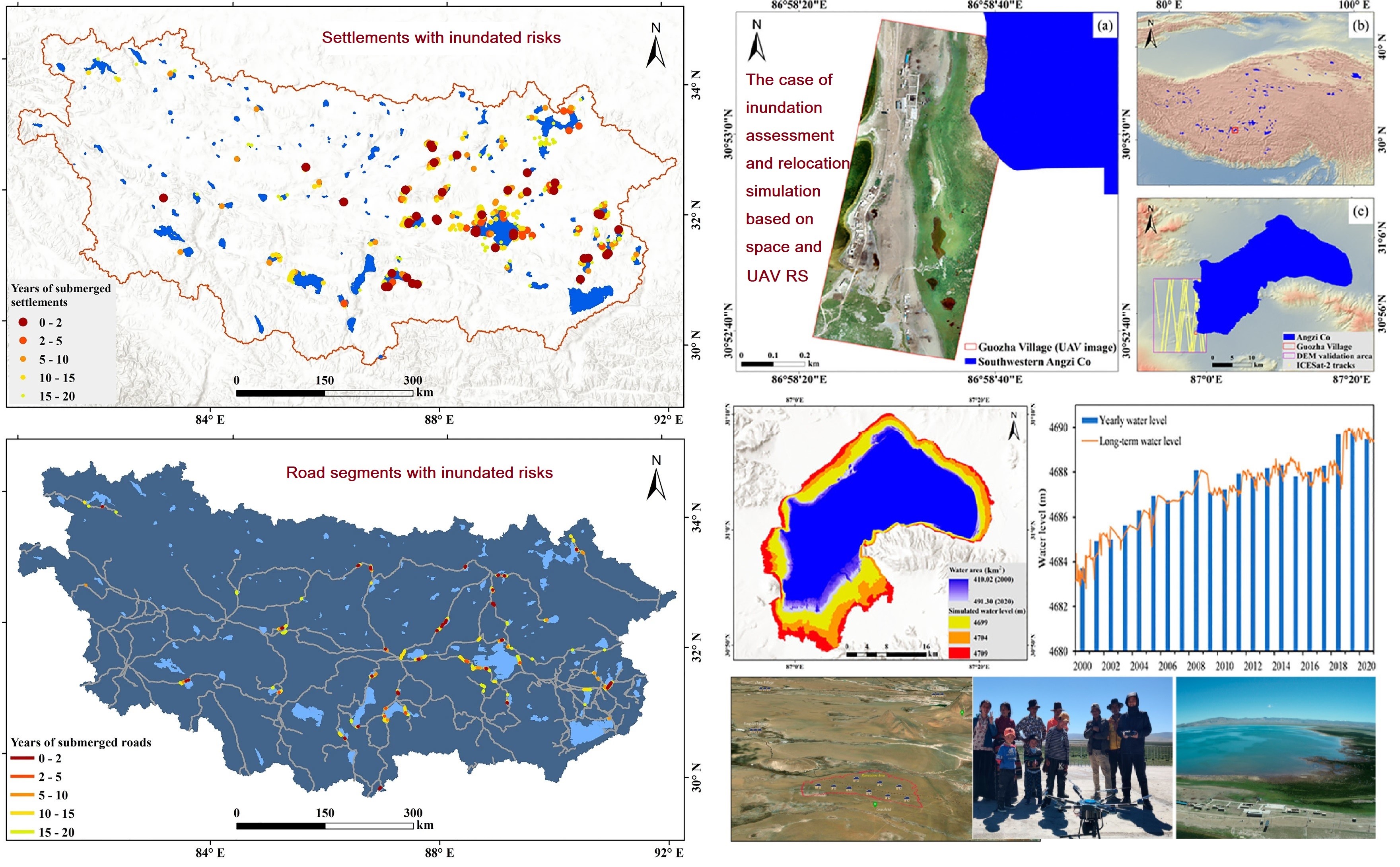
Assessment of the potential flooding risks of the rapid lake expansion on surrounding village settlements and roads and optimization of the relocation case of threatened settlements.
Paper links:
https://www.sciencedirect.com/science/article/pii/S0034425721004995?via%3Dihub
(Remote Sensing of Environment, 2021)
https://www.sciencedirect.com/science/article/pii/S0341816221000369?via%3Dihub
(CATENA, 2021)
https://www.sciencedirect.com/science/article/pii/S0048969721050038?via%3Dihub
(Science of The Total Environment, 2021)
https://link.springer.com/article/10.1007/s12665-021-09470-4
(Earth Environment Sciences, 2021)
https://ieeexplore.ieee.org/document/9459752
(IEEE Geoscience and Remote Sensing Letters, 2021)