A Special Section in JGR Atmospheres: ater-Soil-Air-Plant-Human Nexus: Modeling and Observing Complex Land Surface Systems at River Basin
A Special Section in JGR Atmospheres called Water-Soil-Air-Plant-Human Nexus: Modeling and Observing Complex Land Surface Systems at River Basin, reviews the latest progress in the watershed system models and observation methods. Here, some articles published in the special section are liested below.
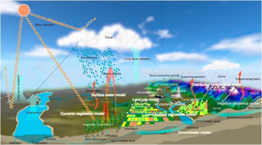
Vision of a watershed system model (Source: Li et al. [2018], Figure 1)
A High‐Resolution Land Model With Groundwater Lateral Flow, Water Use, and Soil Freeze‐Thaw Front Dynamics and its Applications in an Endorheic Basin https://agupubs.onlinelibrary.wiley.com/doi/10.1029/2018JD028369
Abstract
Human water regulation, groundwater lateral flow, and the movement of frost and thaw fronts (FTFs) affect soil water and thermal processes, as well as energy and water exchanges between the land surface and atmosphere. Reasonable representation of these processes in land surface models is very important to improving the understanding of land‐atmosphere interactions. In this study, mathematical descriptions of groundwater lateral flow, human water regulation, and FTFs were synchronously incorporated into a high‐resolution community land model, which is then named the Land Surface Model for Chinese Academy of Sciences (CAS‐LSM). With a series of atmospheric forcings and high‐resolution land surface data from the Heihe Watershed Allied Telemetry Experimental Research (HiWATER) program, numerical simulations of the period 1981–2013 using CAS‐LSM with 1‐km resolution were conducted for an endorheic basin, the Heihe River Basin in China. Compared with observations, CAS‐LSM reproduced the distributions of groundwater, evapotranspiration, and permafrost reasonably and well matched the temporal changes in ground temperature, heat fluxes, and FTFs. Results illuminate the temporal and spatial characteristics of frozen soil and the changes in the land‐atmosphere exchange of carbon, water, and energy. The permafrost and seasonally frozen soil were distinguished. In the seasonally frozen areas, the maximum soil frost depth increased by 0.65 mm/year within natural areas and decreased by 2.12 mm/year in human‐dominated areas. The active layer thickness increased 8.63 mm/year for permafrost. In the permafrost zone evapotranspiration and latent heat flux increased, and the sensible heat flux declined. In the human‐dominated areas water use raised the latent heat flux and reduced the sensible heat flux, net ecosystem exchange, and streamflow recharging to the eco‐fragile region in the lower reaches. Results suggested that the land surface model CAS‐LSM is a potential tool for studying land surface processes, especially in cold and arid regions experiencing human interventions.
Intercomparison of Six Upscaling Evapotranspiration Methods: From Site to the Satellite Pixel
https://agupubs.onlinelibrary.wiley.com/doi/10.1029/2018JD028422
Abstract
Land surface evapotranspiration (ET) is an important component of the surface energy budget and water cycle. To solve the problem of the spatial‐scale mismatch between in situ observations and remotely sensed ET, it is necessary to find the most appropriate upscaling approach for acquiring ground truth ET data at the satellite pixel scale. Based on a data set from two flux observation matrices in the middle stream and downstream of the Heihe River Basin, six upscaling methods were intercompared via direct validation and cross validation. The results showed that the area‐weighted method performed better than the other five upscaling methods introducing auxiliary variables (the integrated Priestley‐Taylor equation, weighted area‐to‐area regression kriging [WATARK], artificial neural network, random forest [RF], and deep belief network methods) over homogeneous underlying surfaces. Over moderately heterogeneous underlying surfaces, the WATARK method performed better. However, the RF method performed better over highly heterogeneous underlying surfaces. A combined method (using the area‐weighted and WATARK methods for homogeneous and moderately heterogeneous underlying surfaces, respectively, and using the RF method for highly heterogeneous underlying surfaces) was proposed to acquire the daily ground truth ET data at the satellite pixel scale, and the errors in the ground truth ET data were evaluated. The Dual Temperature Difference (DTD) and ETMonitor were validated using ground truth ET data, which solve the problem of the spatial‐scale mismatch and quantify uncertainties in the validation process.
Evaluating Different Machine Learning Methods for Upscaling Evapotranspiration from Flux Towers to the Regional Scale
https://agupubs.onlinelibrary.wiley.com/doi/10.1029/2018JD028447
Abstract
Evapotranspiration (ET) is a vital variable for land‐atmosphere interactions that links surface energy balance, water, and carbon cycles. The in situ techniques can measure ET accurately but the observations have limited spatial and temporal coverage. Modeling approaches have been used to estimate ET at broad spatial and temporal scales, while accurately simulating ET at regional scales remains a major challenge. In this study, we upscale ET from eddy covariance flux tower sites to the regional scale with machine learning algorithms. Five machine learning algorithms are employed for ET upscaling including artificial neural network, Cubist, deep belief network, random forest, and support vector machine. The machine learning methods are trained and tested at 36 flux towers sites (65 site years) across the Heihe River Basin and are then applied to estimate ET for each grid cell (1 km × 1 km) within the watershed and for each day over the period 2012–2016. The artificial neural network, Cubist, random forest, and support vector machine algorithms have almost identical performance in estimating ET and have slightly lower root‐mean‐square error than deep belief network at the site scale. The random forest algorithm has slightly lower relative uncertainty at the regional scale than other methods based on three‐cornered hat method. Additionally, the machine learning methods perform better over densely vegetated conditions than barren land or sparsely vegetated conditions. The regional ET generated from the machine learning approaches captured the spatial and temporal patterns of ET at the regional scale.
Hydrological Cycle in the Heihe River Basin and Its Implication for Water Resource Management in Endorheic Basins
https://agupubs.onlinelibrary.wiley.com/doi/10.1002/2017JD027889
Abstract
Endorheic basins around the world are suffering from water and ecosystem crisis. To pursue sustainable development, quantifying the hydrological cycle is fundamentally important. However, knowledge gaps exist in how climate change and human activities influence the hydrological cycle in endorheic basins. We used an integrated ecohydrological model, in combination with systematic observations, to analyze the hydrological cycle in the Heihe River Basin, a typical endorheic basin in arid region of China. The water budget was closed for different landscapes, river channel sections, and irrigation districts of the basin from 2001 to 2012. The results showed that climate warming, which has led to greater precipitation, snowmelt, glacier melt, and runoff, is a favorable factor in alleviating water scarcity. Human activities, including ecological water diversion, cropland expansion, and groundwater overexploitation, have both positive and negative effects. The natural oasis ecosystem has been restored considerably, but the overuse of water in midstream and the use of environmental flow for agriculture in downstream have exacerbated the water stress, resulting in unfavorable changes in surface‐ground water interactions and raising concerns regarding how to fairly allocate water resources. Our results suggest that the water resource management in the region should be adjusted to adapt to a changing hydrological cycle, cropland area must be reduced, and the abstraction of groundwater must be controlled. To foster long‐term benefits, water conflicts should be handled from a broad socioeconomic perspective. The findings can provide useful information on endorheic basins to policy makers and stakeholders around the world.
Large Hydrological Processes Changes in the Transboundary Rivers of Central Asia
https://agupubs.onlinelibrary.wiley.com/doi/10.1029/2017JD028184
Abstract
Central Asia, which is one of the most complex regions in the world, is crisscrossed with transboundary rivers shared by several countries. This paper analyzes the effects of climate change and human activities on hydrological processes and water resources in these transboundary rivers over the past half century. The results show that the average temperature in the Tienshan Mountains experienced “sharp” increases in 1998, with the average temperature after 1998 being 1.0°C higher than that during 1960–1998. This rapid warming has accelerated glacier shrinkage and decreases in snow cover. These changes influenced the hydrological processes, causing an earlier runoff peak and aggravated extreme hydrological events. Changes in mountainous hydrological processes affected regional water availability and intensified future water crisis in Central Asia. The mismatched spatial distributions of water and land resources, along with the intense human activities (e.g., overexploitation of water resources), have ultimately led to the present water crisis in Central Asia's river basins. This is the main reason for ongoing water conflicts in the region's transboundary rivers and the ecological disaster of the Aral Sea.