Satellites Reveal Hotspots of Global River Extent Change
Rivers are one of the most dynamic water cycle components of the earth surface and hold fundamental economic and ecological significance for the development of human societies, ecosystem sustainability, and regional climate. Their natural balance has been threatened by a wide range of anthropogenic stressors and ongoing climate change.
With increasing demands for social-economic development, human disturbances in the form of dam construction, aquaculture, and irrigation have resulted in large-scale and rapid transformations of river channels. However, characterizing and understanding such changes have been challenging from a long-term and global perspective.
Researchers led by Prof. SONG Chunqiao from the Nanjing Institute of Geography and Limnology and collaborators from multiple institutes in China and the United States, have revealed a global attribution of the recent changes in river regime to morphological dynamics (e.g., channel shifting and anabranching), expansion induced by new dams, and hydrological signals of widening and narrowing, by analyzing water extent variations observed from four-decade Landsat imagery.
The research findings were published in Nature Communications on March 22, 2023.
“Morphological dynamics prevailed in about 20% of the global river area.” said Prof. KE Linghong, a primary author of this research paper. “On this type of river basin, high percentages of narrowing and widening are observed along different banks of river reaches, which are associated with the variations of flow regimes of meandering, braided, anabranching or wandering river channels.”
“Booming reservoir constructions, mostly skewed in Asia and South America, contributed to 32% of the river widening,” said Prof. SONG.
“The remaining hydrological signals were characterized by contrasting hotspots, including prominent river widening in alpine and pan-Arctic regions and narrowing in the arid/semi-arid continental interiors, driven by varying trends in climate forcing, cryospheric response to warming, and human water management,” said by Ms. WU Qianhan, another primary author.
“Our analysis provides a global-scale but spatially-explicit guidance for better prioritizing future river protection and restoration efforts under the United Nations 2030 Agenda for Sustainable Development, which calls on international actions to track the spatial extent and condition of water-related ecosystems,” said Prof. SONG.
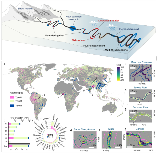
The global distribution of different types of river extent changes in the early 21st century: morphological dynamics (Type-M), hydrological signals (Type-H), and new reservoir-type river reaches (Type-R). (Image by Prof. SONG Chunqiao)
Link:https://www.nature.com/articles/s41467-023-37061-3.
Contact
TAN Lei
Nanjing Institute of Geography and Limnology
E-mail: ltan@niglas.ac.cn